Go Back
Hispaniola Humpback Whales

Charcoal on a 33 x 44 inch 1912 nautical map of the Dominican Republic.
My Vintage Map Series primarily focuses on threatened and endangered species. Whenever I am given an old map, my first step is to do a web search of the area. In 2023 I was given this folded 33 x 44 inch antique nautical map of the north coast of the Dominican Republic (aka Hispaniola).
In researching this map I discovered Silver Bank. Silver Bank was established in 1986 and is the largest protected sanctuary for mating and calving of North Atlantic Humpback Whales. It is 56 miles north of Puerto Plata (which is on this map) where ships depart to take tourists to see the whales.
These giant baleen whales were hunted to near extinction. Known for their songs and 10K long migrations, they now number over 100,000, thanks to the protection afforded by the Endangered Species Act of 1973 and sanctuaries like Silver Bank.
Fatu Hiva Monarch Bird

Charcoal on a 20 x 24 inch antique nautical map of Fatu Hiva Island.
I am intensely interested in our human impact on the planet. This is why my Vintage Map series emphasizes endemic, threatened, and endangered species.
I was given a 104-year-old maritime map of Fatu Hiva Island after my show at the Channel Islands Maritime Museum in late 2022. In researching the island I discovered one of the most endangered species in the world, the bird the Fatu Hiva Monarch.
This monarch is critically endangered. There are only seventeen birds left. Pairs mate for life and females lay only one egg at a time. They are on the brink of extinction.
Fatu Hiva is a small island of the Marquesas Islands, in French Polynesia with a population of 600. There is no airstrip on Fatu Hiva and it can only be reached by boat. In the 1980s black rats invaded the island from boats. Cats also came with tourists and between rats, cats and avian malaria, the Fatu Hiva Monarch declined rapidly to the seventeen that are remaining now.
There are so few monarchs on the island that half the people living on Fatu Hiva have never seen one. The SOP, Société d′Ornithologie de Polynésie (The Polynesian Ornithological Society), also called SOP Manu, was founded in 1990, is committed to saving the most endangered birds in French Polynesia. The SOP with the Auckland Zoo, and other NGOs collaborate in saving the monarch from extinction. They use various interventions such as artificial incubation, setting up nets to protect nesting areas, keeping rats and cats away, and working with the locals.
The French biologist and photographer for the SOP, Benjamin Ignace (www.bigcaptures.com), is the adventurous and talented photographer who generously gave me permission to use his photographs for the bird and the chick in the nest.
A note about the map: This is the 6th edition printed in 1920 of a map first created in 1889. It is a beautifully drawn map that is divided into three sections: One has the entire island where I placed the adult monarch (actual size) and the chick within the nest; The other two are of Hana Vave and Omoa, the two bays that sailors need to land on the island. I could not resist drawing the rocks that inspired sailors to call Hana Vave, Penis Bay. Missionaries did not like the sailor′s name for the bay, so they renamed it Virgins Bay. I also drew the Polynesian woman on Omoa Bay as women have dressed for thousands of years before the missionaries.
I hope my art inspires people to remember our shared responsibility to our beautiful planet and all its precious inhabitants.
To learn more about the Fatu Hiva Monarch and the people committed to saving them from extinction:
Tuamotu Kingfisher

Charcoal and colored pencil on a 20 x 24 inch antique nautical map of Amanu Atoll.
The Niau Kingfisher, also known as the Tuamotu Kingfisher, is one of the most critically endangered birds in the world. There are only 125 left on the atoll of Niau in French Polynesia. The Niau Kingfisher is being protected by the farmers of Niau, who know not to cut down all the dead palm trees because that is where the kingfisher nests, and environmentalists from universities around the world who continue to monitor the species.
Since I do not have a vintage nautical map of the Niau Atoll, I drew it on a beautiful 100+ year old map of the Amanu Atoll. I am taking artistic license and imagining that this gorgeous bird was living throughout the French Polynesian archipelago thousands of years ago and might have lived on Amanu. I love how the cartographer drew the palm trees and vegetation on this map and did not want my artwork to compete with it. I stared at this map for four months until it came to me where to place the kingfisher so as not to distract from the artwork of the map.
Palmyra Red–footed Booby

Charcoal and colored pencil on a 30x40 inch vintage nautical map.
The Palmyra Atoll, titled Palmyra Island on this map, is a ring of pristine, coral-fringed islets nearly 1000 miles south of Hawaii in the Pacific Ocean. It has no permanent human residents. The British first surveyed it in 1897. During WWII the US Secretary of the Navy updated and published this map in July of 1942 for ships to navigate the atoll. Notice “Restricted” printed on the bottom.
During WWII Palmyra was a refueling station for the Navy with 6000 sailors stationed there. The ships that came also brought a host of stowaway black rats to the islands. For decades the rodents thrived on Palmyra, quickly multiplying while devouring young crabs, seeds, tree seedlings, the eggs and chicks of the Red-footed Booby and other seabirds. Rats decimate seabird populations.
The Nature Conservancy (TNC) purchased the atoll in 2000 and sold half to the U.S. Fish and Wildlife Service (FWS). They partnered with the National Oceanic and Atmospheric Administration (NOAA), whose mission is to conserve the ocean and its remote islands and atolls, including Palmyra.
The invasive black rats, and the Asian Tiger mosquitos that fed off the rats, were successfully eradicated in 2011 from Palmyra as the result of a joint project of the FWS, and Island Conservation, whose mission is to prevent extinctions by removing invasive species from islands.
Environmentalists were amazed to see that within one month of the eradication project, the atoll's native flora and fauna began to return and thrive.
The Red-footed Booby nests in Pisonia trees. Since the rats were no longer eating the seeds and seedlings of the trees, the trees began to flourish. The Red-footed Booby′s population increased, and so did their guano. The birds′ guano not only fertilized the islands of Palmyra, but also the coral reefs surrounding them. It is now a wildlife refuge with strict restrictions for visitation and research. Environmental scientists around the world study Palmyra as evidence that the balance of nature returns when invasive species are eliminated.
Channel Islands Pygmy Mammoth

Charcoal on a 20 x 26 inch USGS map of Santa Rosa Island.
The Channel Island Pygmy Mammoth lived nowhere else in the world but on the Channel Islands.
Approximately 40,000 to 20,000 years ago, a group of 14 foot tall, 20,000 pound Columbian mammoths swam the six miles from the mainland of California to the superisland of Santarosae.
In the last 20,000 years, with melting glaciers, the ocean waters rose 300 feet and submerged 75% of Santarosae; creating the four separate islands of Anacapa, Santa Cruz, Santa Rosa, and San Miguel.
Natural selection favored smaller–sized mammoths that stood less than 6 feet tall at the shoulder and weighed only 2000 pounds. The new species adapted to the smaller land areas, ate vegetation other than grasses, and their shortened legs had the ability to easily climb steep cliffs and mountains.
The small mammoths became a new species, the Channel Islands Pygmy Mammoth. A nearly complete fossilized skeleton was discovered on Santa Rosa Island in 1994 of a fifty–four year old male pygmy mammoth that died about 13,000 years ago. A remarkable discovery, indeed!
Without The Bald Eagle The Island Fox Would Be Extinct / Diptych

Each is a charcoal and pastel drawing on a 20 x 26 inch historical USGS topographic map of the middle of Santa Cruz Island.
The Santa Cruz Island Fox was on the brink of extinction in 2000 with only 80 foxes left. Bald eagles controlled the skies and ate small sea birds and fish. Montrose Corporation dumped DDT into the ocean starting in 1947 that poisoned the fish the bald eagles ate. DDT thins the shells of large birds and causes them to break. Bald eagles were extinct on the Channel Islands by 1960.
With bald eagles gone, golden eagles took their place. They first preyed on feral pigs. From 1994 to 2000 they ate most of the Island Foxes. The Island Fox was saved from extinction by capturing and moving the golden eagles inland, returning bald eagles to the islands, and putting the foxes in a captive breeding program until the balance of nature returned.
By 2019 there were 2,462 Santa Cruz Island Foxes and 50 bald eagles that kept golden eagles away. The Island Fox has the fastest recovery of an endangered species in the history of the Endangered Species Act of 1973.
Monterrey Bay Two–Spot Octopus

Charcoal on a 26 x 20 inch vintage map of Monterrey.
This image won First Place in Studio Channel Islands Art Center′s “Collectors Choice” show juried by Sarah Russin in 2021.
Besides the nice prize money, it also awarded me a future show in the main gallery.
The Two–Spot Octopus is endemic to California. Its range is between the middle of California down to Baja California. Its name comes from the two blue spots on each side of its head behind its eyes.
Octopuses are notorious for their camouflage techniques, they can blend in with the environment so well that they will go unnoticed by many of their predators as well as many of their prey.
This map of Monterrey Bay was my best choice for drawing the California Two–Spot Octopus because of how in fits in the shape of the bay. I considered many animals to draw in the bay, including otters, but settled on the octopus. I alway incorporate the shapes on a map with the animal I draw on it. This is also the first of my Vintage Map Series in which I used tinted charcoal for the water.
Yosemite Means Grizzly Bear

Charcoal on a 31 x 32 inch vintage map of Yosemite National Park that was printed in 1958.
This map of Yosemite was taped to cardboard and hung from my father–in–law′s ceiling in his garage library in Tehatchapi for well over twenty years. I was given the map in 2017 when the house was sold. I held on to the map for three years waiting for inspiration to add it to my Vintage Map Series of charcoal drawings on California maps. While researching Yosemite I learned that the word Yosemite means Grizzly Bear.
I further learned that there were an estimated 10,000 grizzlies living in California in the late 1700′s. Within seventy–five years after the Gold Rush every grizzly bear in CA was tracked down and killed. The California Grizzly Bear was extinct by 1924.
The Grizzly Bear on the flag of California was modeled after a grizzly named Monarch that was taken from the mountains of Ventura County in 1989 to live his next 22 years in a small cement and metal cage in the zoo at Golden Gate Park. When Monarch died he was stuffed and put on display. It is the stuffed Monarch that was the model for the bear on the California State Flag. An extinct species is on our state flag. Sigh.
However, to honor these great beasts, I drew one from a photograph of a living grizzly. They are thriving in Alaska and Western Canada. There are still small populations of grizzlies in Idaho, Montana and Wyoming. I celebrate the California Grizzly Bear on its namesake park, Yosemite.
Snohomish Coyote Couple

Mixed media on a 17 x 14 inch vintage map of Washington containing Snohomish.
Thank you to Peggy Faranda who has been photographing this pair visiting her property since 2013 with their puppies. She named them Mama and Papa. In 2017 she cured them of mange by feeding them raw chicken with medicine in it. Peggy has many wild animals visit her property. She is an advocate for wildlife and a terrific photographer.
John Knapp and the Santa Cruz Island Fox

Mixed media collage on a 14 1/2 x 17 1/2 inch vintage map containing Santa Cruz Island.
This Island Fox lives only on Santa Cruz Island. The photographs in squares are of John Knapp, botanist for the Nature Conservancy on Santa Cruz Island looking at an Island Fox. I printed the photos on vellum to show how really tiny the fox is in comparison to a human. They weigh about 3 lbs. Beautiful, tiny creatures.
Santa Cruz Island Scrub Jay

Mixed media on a 22 x 26 inch historical USGS topographic map of the middle of Santa Cruz Island.
This drawing shows the actual size of an Island Scrub Jay. It is 30% larger than the California scrub jay, from which it has evolved. It also has a much more vibrant blue color. It lives nowhere else in the world but Santa Cruz Island.
The Island Scrub Jay is an example of gigantism. The “Bread Box Theory” explains what happens when animals become isolated on an island: If they are smaller than a breadbox, they become giants. If they are bigger than a breadbox, they shrink (like the Pygmy Mammoth).
About 150,000 years ago the Island Scrub Jay′s ancestors flew to the huge island of Santa Rosae, which was five miles from the California shore. Then the ocean rose 300 feet as ancient glaciers melted and covered most of Santa Rosae. This left the separate islands of Anacapa, Santa Cruz, Santa Rosa, and San Miguel. Only Santa Cruz Island still has this lovely bird.
Bear Harbor Brown Pelican

Charcoal on 20 x 26 inch vintage map containing Bear Harbor in Northern California.
The establishment of the Channel Islands National Park in 1980 helped save the Brown Pelican from extinction by protecting their breeding grounds. All Brown Pelicans up and down the coast of California breed in the Channel Islands. The only long–term breeding colonies of California Brown Pelicans in the United States are on Anacapa and Santa Barbara Islands.
Brown Pelicans were listed as endangered in 1970. The cause of the population decline and the threat of extinction was DDT, manufactured by Montrose Corporation, which caused egg shell thinning and the eggs to break during incubation of all large birds where DDT was used across the United States. Since Rachel Carson′s Silent Spring, the world has known of DDT′s destructive impacts. DDT was banned in 1972 in the United States but is still being sold overseas. Dumped barrels of DDT are leaking in the Pacific Ocean by the Channel Islands today and Montrose needs to take responsibility for this tragedy and clean up their mess.
Triple Topographical Tortoises

Charcoal on a 17 x 20 inch vintage topographical map containing Lost Horse Mountain California.
The California Desert Tortoise was placed on both the California and Federal Endangered Species Lists in 1989 and 1990, respectively. Its status is “threatened”, just one notch below “endangered”. It is estimated that desert tortoises have existed for 15 to 20 million years. One of the best websites to learn about this amazing species is on the Joshua Tree National Park website, www.nps.gov/jotr/learn/nature/tortoise.htm
It took me three years to commit to drawing a tortoise, and I ended up drawing three of them on this 1958 10 cent topograhic map from my inherited collection of old maps. This is the first drawing that I did on a topographic map. All the previous ones were on camping maps. I really had fun with this one! First I drew the top tortoise as realistically as I could with all its wrinkles and plates. Then I followed the topographic lines to create the shadow/mirror image under the top tortoise. It created this weird negative space between them. I drew the bottom one with less detail and more map showing through. It was juried into The Next Big Thing 2020 by the Leah Ollman who writes about the visual arts for the Los Angeles Times, Art in America and numerous other publications.
Bay Area Sea Lion

Charcoal on 26 x 20 inch vintage map containing Bear Harbor in Northern California.
Even though you can see sea lions up and down the coast of California, their rookeries are in the Channel Islands.
Do you know the difference between the a sea lion and a seal? Sea lions have ear flaps, walk on all fours, are very noisy, and are extremely social. Seals have no visible ear flap, drag their hind flippers as they crawl on their bellies, make soft noises, and are loners (except in mating season). The California Sea Lion is native to North America and the Channel Islands National Park is the breeding ground for sea lions in California.
Lassen Wolves

Charcoal on 20 x 26 inch vintage map containing Lassen Volcanic National Park in Northern California.
Wolves have been gone from California for almost 100 years. The Lassen Pack is California′s only known wolf family, first confirmed within the state in the Fall of 2016. They are monitored by the California Department of Fish & Wildlife to help them survive. They are doing well.
I recommend watching the Youtube documentary, “How Wolves Change Rivers.” It is about reintroducing wolves to Yellowstone National Park and their importance in stabilizing the ecosystem.
“Lassen Wolves” is the first of my Vintage Map Series where I let much more of the map show through the animals.
Modoc Bobcat

Charcoal on a 20 x 26 inch vintage camping map containing Modoc California.
Bobcats can be found everywhere in California. I drew this bobcat on tracing paper before I chose the map location. I was really happy with my drawing until I realized it was too small and would be lost compositionally on a full page of map lines. I was thrilled to find map #8 which had less map lines and more white space — hence the bobcat became a Modoc Bobcat.
The Bobcat Protection Act of 2013 protects them from trapping and hunting in national parks, monuments, and wildlife refuges. Rat poison kills bobcats, cougars, and birds of prey if they eat the poisoned rodents. Do not use rat poison.
Modoc Bobcat is the first piece of art that I entered into a professional art show in over thirty years. The Next Big Thing 2018 at the Blackboard Gallery at Studio Channel Islands Art Center in California, was juried by Peter Frank, internationally recognized art critic and curator of contemporary art. This piece marks the return of my life as a professional artist.
Joshua Tree Cottontail

Charcoal on a 20 x 26 inch vintage camping map containing Joshua Tree California.
You can tell that the cottontail in this drawing is on hight alert because it has its white tail up to warn other cottontails of danger. Cottontail rabbits can be found all over California. Anyone living in the Conejo Valley (Spanish for Rabbit Valley) is used to seeing cottontails on their lawns because their primary diet is grass. Dessert cottontails also eat catcus, prickly pear pads and other desert plants.
Joshua Tree Cottontail (2019) was my second piece to be accepted into a major juried show, The Next Big Thing 2019, at the Blackboard Gallery at Studio Channel Islands Art Center in California. The show was juried by Mat Gleason, Los Angeles art critic and curator of contemporary art.
Oroville Red–Legged Frog

Charcoal and Pastel on a 20 x 26 inch vintage camping map containing Oroville California.
Mark Twain immortalized the red–legged frog in his 1865 story titled “The Celebrated Jumping Frog of Calaveras County.” The California red–legged frog is the largest native frog in the western United States. Named for its red abdomen and hind legs, the frog was once found in 46 counties in California and south to Baja California, Mexico. Unfortunately, the frog was listed as threatened in 1996.
Habitat loss and alteration, as well as non–native species, are the primary factors that have negatively impacted the California red–legged frog throughout its range. In the Central Valley of California, more than 90% of historic wetlands have been diked, drained or filled, primarily for agricultural development and secondarily for urban development. Poisons used in agriculture are also to blame.
I first researched the red–legged Frog in June of 2020 for this drawing. Lake Oroville was one of its critical habitats at that time. Note: Since this camping map was issued before the Lake Oroville dam was constructed (construction began in 1957) there is no lake on this CA map #15. I did not realize how prophetic it was to place the circle of frogs in disappearing stages around where the lake is now. Sadly, as of September, 2022, I find no evidence of red–legged frogs anywhere near Oroville.
However, there is good news for the survival of the red–legged frog because many organizations are working diligently to save this species from extinction: The National Wildlife Federation, Save the Frogs, Partners for Fish and Wildlife Program, Wheatley Ranch, U.S. Fish and Wildlife Service, U.S. Geological Survey, Fauna del Noroeste (Fauno), The Nature Conservancy, San Diego Natural History Museum, San Diego Association of Governments, U.S. Forest Service (Cleveland National Forest), California Department of Fish and Wildlife and Riverside County Parks.
Buttonwillow Tule Elk

Charcoal on a 20 x 26 inch vintage map containing Buttonwillow California.
Map #43 contains “adopted State Hwy 5” running through the tail of the Tule Elk. I–5 was completed in 1957, which tell us that this map series was printed before that time.
The Tule Elk are endemic to (live only in) California. They were hunted to near extinction in the 1800′s until 1874 when cattleman Henry Miller began efforts to save the very few that survived by protecting them on his land. In 1932 the herd was given permanent protection on the land near Buttonwillow, now known as the Tule Elk State Natural Reserve. How many times, when driving on I–5, have I passed the sign to The Tule Elk State Natural Reserve with no thought that the endemic Tule Elk would be extinct if not for this reserve? Thank you, Henry Miller!
Sequoia Bighorn Sheep
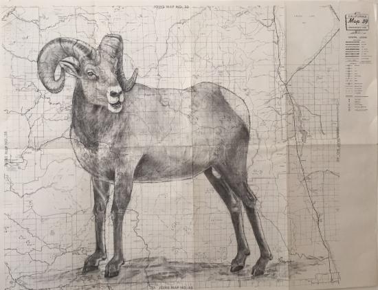
Charcoal on a 20 x 26 inch vintage map containing Sequoia California.
Yosemite Gray Fox

Charcoal on a 20 x 26 inch vintage map containing Yosemite National Park.
This Yosemite Gray Fox is the very first drawing of my Vintage Map Series. The California Gray Fox is the ancestor to the tiny Island Fox found only on the Channel Islands off the coast of Southern California. Teaching my students about the Island Fox and how to draw them was how I got interested in drawing animals, which lead to this Vintage Map Series.
Lone Woman of San Nicolas Island

Charcoal on a 27 x 22 inch vintage topographic map of San Nicolas Island.
The Lone Woman of San Nicolas Island is the first of my Channel Island Vintage Map Series to honor any of the native people of the Channel Islands.
Many people know about the Lone Woman of San Nicolas Island from the 1960 Newberry Award winning book, Island of the Blue Dolphins by Scott O′Dell. The novel is based on the true story of a Nicoleño Indian woman who was left behind when her people were removed from San Nicolas Island in 1835.
We now know that about 200 of her people, the Nicoleños, lived on San Nicolas Island for at least 8,000 years. They were closely related to the Tongva of modern day Los Angeles. A horrific Genocide in 1814 by a party of Aleut and Russian fur hunters left the Nicoleño population decimated. Years later, in 1835, missionaries sent a ship to bring the less than twenty surviving Nicoleños to San Pedro, California. Many of them died from European diseases for which they had no immunity. All of them lost their homes, communities, freedom, and self–reliance.
The Lone Woman, however, was not on that ship. She continued to live on San Nicolas Island for the next eighteen years. In 1853 Captain George Nidever “rescued” her from her island home of nearly sixty years to bring her to Santa Barbara where she died of dysentery seven weeks later. Missionaries baptized her Juana Maria after she was already dead. Unfortunately, no one spoke her language; she died with her real name unknown and her story mostly untold.
Nidever described her in his journal as a woman in her late fifties, with shoulder length hair, wearing a dress of cormorant feathers. Since there are no photographs of her, I portrayed her as courageous, strong and weathered from a lifetime working in the sun.
I am deeply saddened by our country′s history of mistreatment, slavery, and genocide of Native Americans. As a California artist living two hundred years after the Nicoleños were removed from their ancestral home, I hope to honor the Lone Woman of San Nicolas Island and her people with this artwork and by telling their story.
Louise Gipe and the St. Francis Dam Disaster

Mixed media on a 17 x 20 inch historical topographical map containing the San Francisquito Canyon.
I want to celebrate courageous women who are little known in American history. In 1928 the St. Francis Dam′s reservoir supplied 85% of the water to Los Angeles. It held 12 1/2 billion gallons of water. Right before midnight on March 12, 1928, the twenty story high dam catastrophically failed, sending a deadly flood of water that destroyed everything in its path for 54 miles from San Francisquito Canyon all the way to the Pacific Ocean. Louise Gipe was the telephone operator that night in Santa Paula who is responsible for saving countless lives by calling to warn people to get to high ground before their homes were washed away. She was willing to risk her own life to save others. The St Francis Dam′s failure is the worst man–made disaster in California′s history. Between 500 and 1000 people were killed. There are many people who owe Louise Gipe a debt of gratitude. FLOODPATH by John Wilkman is a fascinating book if you want to learn about the making of modern Los Angeles, William Mulholland, and this great tragedy.
Guaranteed GI Loans in Reseda, 1950 (only if you′re white)
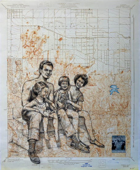
Mixed media on a 17 x 21 inch historic USGS topographic map, printed in 1945.
This is my family in 1952 sitting on the back steps of our porch of the house in Reseda that my folks bought in 1950 with the GI Bill. They only paid $49 down and $49 a month because my dad was a 101st Airborne Paratrooper who jumped in Normandy. Buying this house brought my parents into the middle class. 8 million white veterans, like my dad, got the benefits from the GI Bill. Of the 1.2 million Black soldiers who fought in WWII, less than 100 got them. Outrageous injustice!
Frances Perkins, the Woman Behind the New Deal as FDR′s Secretary of Labor
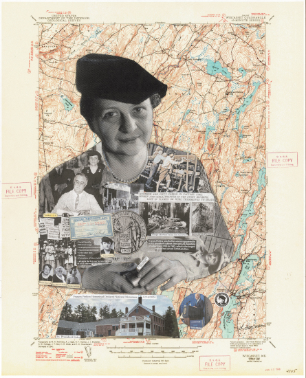
Collage, Charcoal & Ink on a 22 x 26 1/2 inch Vintage Topographic Map Containing New Castle, Maine.
I created this collage after reading about the creation of the newest National Monument in honor of Frances Perkins. There are now 139 National Monuments. Of these there are only seventeen (17/139) National Monuments honoring significant American women.
The following is an excerpt from the Proclaimation on the Establishment of the Frances Perkins National Monument by the President of the United States of America by then president, Joe Biden, signed on December 16, 2024.
Few Americans have had deeper influence in shaping labor and social policy in the United States than Frances Perkins. Perkins became the first woman to serve as a Cabinet Secretary when President Franklin Delano Roosevelt appointed her as the Secretary of Labor in 1933. During the subsequent 12 years, Secretary Perkins played a pivotal role in constructing the New Deal and helping to guide the country out of the Great Depression by designing and leading the implementation of sweeping labor and economic reforms that have made life better for generations of Americans. The longest serving Secretary of Labor in United States history, Secretary Perkins was the architect of many programs and standards — including a minimum wage, overtime pay, unemployment insurance, and prohibitions on child labor — that have endured as the backbone of Federal support for workers and families and continue to benefit millions of Americans today. Secretary Perkins chaired President Roosevelt′s effort to investigate the benefits of social insurance and then worked to achieve passage of the Social Security Act, which became one of the most successful programs in the United States to prevent poverty among older adults. When the United States and other nations initially failed to face the horrors of the Holocaust, Secretary Perkins demonstrated leadership on behalf of immigrants and refugees by actively working to bring Jewish children and adults from Europe to the United States to ensure their safety.
The Perkins Homestead in Newcastle, Maine, played a pivotal role in Frances Perkins′ life and supported her work to deliver lasting protection and benefits to American workers and families. The rural setting of the Perkins Homestead on the Damariscotta River was the place she felt most at home.
The Grimké Sisters, First White Southern Women Abolitionists & Suffragists of the Early 1800′s
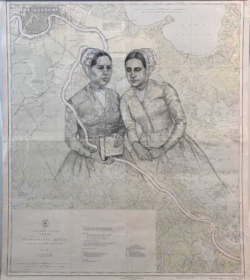
Charcoal on a 33 X 39 inch vintage nautical chart of the Mississippi River and New Orleans.
This double portrait is on a vintage nautical chart of the Mississippi River with New Orleans, historically a huge slave trade center, on the upper left hand corner of the map.
Two early and prominent activists for abolition and women′s rights, Sarah Grimké (1792-1873) and Angelina Grimké Weld (1805-1879) were raised in the cradle of slavery on a plantation in South Carolina. The Grimké Sisters, as they were known, grew to despise slavery after witnessing its cruel effects at a young age.
The sisters′ conversion to Quakerism and subsequent move to Philadelphia made them virtual outcasts in the South, but they also found themselves at odds with many northerners after William Lloyd Garrison published a personal letter Angelina wrote to him in The Liberator.
In 1836 Angelina wrote her “Appeal to the Christian Women of the South” imploring white southern women to embrace the antislavery cause.
Her writing drew the ire of southerners who opposed its abolitionist message and northerners who felt that women had no business writing or speaking about something as controversial as slavery.
This outcry over women abolitionists prompted Sarah to write “Letters on the Equality of the Sexes”. By the late 1830s the Grimke sisters were known not only as abolitionists but also as proponents of women′s rights.
Angelina and Sarah were invited to speak publicly to a group in New York City in the fall of 1836. This launched a new phase of their activist careers. The sisters traveled all over the Northeast giving talks on abolition and women′s rights. Their perspectives on the question of slavery were highly valued because they had grown up in a slave-holding family and understood the system more intimately than most Northern abolitionists.
Angelina was considered one of the most powerful speakers in the abolitionist movement. In 1838, she became the first American woman to address a legislative body when she spoke about abolition and women′s rights in front of the Massachusetts state legislature.
In 1839 the sisters wrote a book with Angelina′s husband, Theodore Dwight Weld, titled, American Slavery AS IT IS: Testimony of A Thousand Witnesses. It was a very powerful book that influenced the abolitionist movement, including Harriet Beecher Stowe. Stowe used it as an inspiration for her 1852 novel, Uncle Tom′s Cabin, which had a profound effect on attitudes toward African Americans and slavery in the U.S., and is said to have helped lay the groundwork for the American Civil War.
I recommend you read The Grimké Sisters From South Carolina, Pioneers for Women′s Rights and Abolition by Gerda Lerner, for a deeper insight into these courageous women.